N
Originally published by Nation Newstop
March 14, 2026
2w ago
Choppers map Nairobi’s hidden aquifers
The second phase of the project will involve "banking" rainwater by injecting it directly into strategic boreholes to prevent the ground from collapsing due to depletion...
✨ Key Highlights
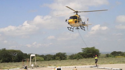
The Kenyan government, in partnership with the Danish Embassy, is employing high-tech helicopter-based electromagnetic sensors to map the groundwater aquifers beneath Nairobi and its surrounding metropolitan area.
- This initiative, part of the Sh200 million GROWANA project, aims to identify and artificially replenish depleted aquifers to address the city's significant long-term water supply deficit.
- Key organizations involved include the Ministry of Water and Sanitation, the Regional Centre on Ground Water Resources, and the Athi Water Works Development Agency.
- The aerial mapping technology can probe depths of at least 350 meters and is crucial for informing strategies to prevent water rationing and potential land subsidence due to groundwater depletion.
Continue Reading
Read the complete article from Nation News
Advertisement

Advertisement